Future of Earth Observation
•
Peek into the horizon of Earth observation, where upcoming missions and cutting-edge technologies promise to revolutionize our understanding of the planet. Building on the legacy of NASA's EPIC camera and DSCOVR spacecraft, these advancements will deliver higher-resolution data, broader coverage, and real-time insights into climate, ecosystems, and disasters. On DailyEarthView.com, we're excited to potentially integrate data from these future sources, enhancing our daily views and archive with even more dynamic planetary motion. Let's explore what's on the launchpad and beyond.
Upcoming Missions
NASA and international partners are gearing up for a new wave of satellites that will expand Earth monitoring capabilities. As of February 2026, recent announcements highlight missions focused on atmospheric dynamics, surface changes, and solar influences.
Earth System Explorers (ESE) Missions
In early February 2026, NASA selected two missions under this program, each capped at $355 million, with launches expected no earlier than 2030.
STRIVE (Stratosphere Troposphere Response using Infrared Vertically-resolved light Explorer)
Led by the University of Washington, this mission will provide daily, high-resolution measurements of temperature, atmospheric gases, and aerosols from the upper troposphere to the mesosphere. It aims to improve forecasting of environmental events and disaster mitigation.
EDGE (Earth Dynamics Geodetic Explorer)
Headed by UC San Diego's Scripps Institution of Oceanography, EDGE will map the 3D structure of terrestrial ecosystems and the topography of glaciers, ice sheets, and sea ice with centimeter-level precision. As the first global satellite imaging laser altimeter, it will enhance our tracking of climate impacts like melting ice.
GLIMR (Geosynchronous Littoral Imaging and Monitoring Radiometer)
Slated for 2026-2027, this instrument will observe ocean biology, chemistry, and ecology in the Gulf of Mexico and beyond for up to 15 hours daily from geosynchronous orbit. It will aid in managing ecosystems, resources, and hazards like oil spills.
Libera
Launching in 2027 on NOAA's JPSS-3, Libera will continue decades of Earth's radiation budget measurements, crucial for understanding climate warming. Developed at the University of Colorado, it builds on CERES instruments.
Sentinel-6B
The European-led follow-up to Sentinel-6 Michael Freilich, launching in 2025 but extending into 2026 operations, will sustain sea-level rise monitoring for climate studies.
These missions will complement EPIC's full-disk views with specialized data, potentially enriching our site's historical comparisons.
Emerging Technologies
The future of Earth observation isn't just about new satellites—it's about smarter systems leveraging AI, constellations, and advanced sensors.
AI and Networked Constellations
By 2026, experts predict fleets of interconnected satellites forming orbital data centers, using AI to process vast datasets in real time. This could handle everything from weather prediction to resource monitoring, with agencies like NASA, ESA, and private firms like Starlink expanding global connectivity.
Advanced Sensors and Orbits
Innovations like laser altimeters (as in EDGE) and hyperspectral imaging will reveal finer details of Earth's systems. Geosynchronous orbits, as with GLIMR, enable continuous regional monitoring, while L1-like positions continue for solar and space weather.
International Collaborations
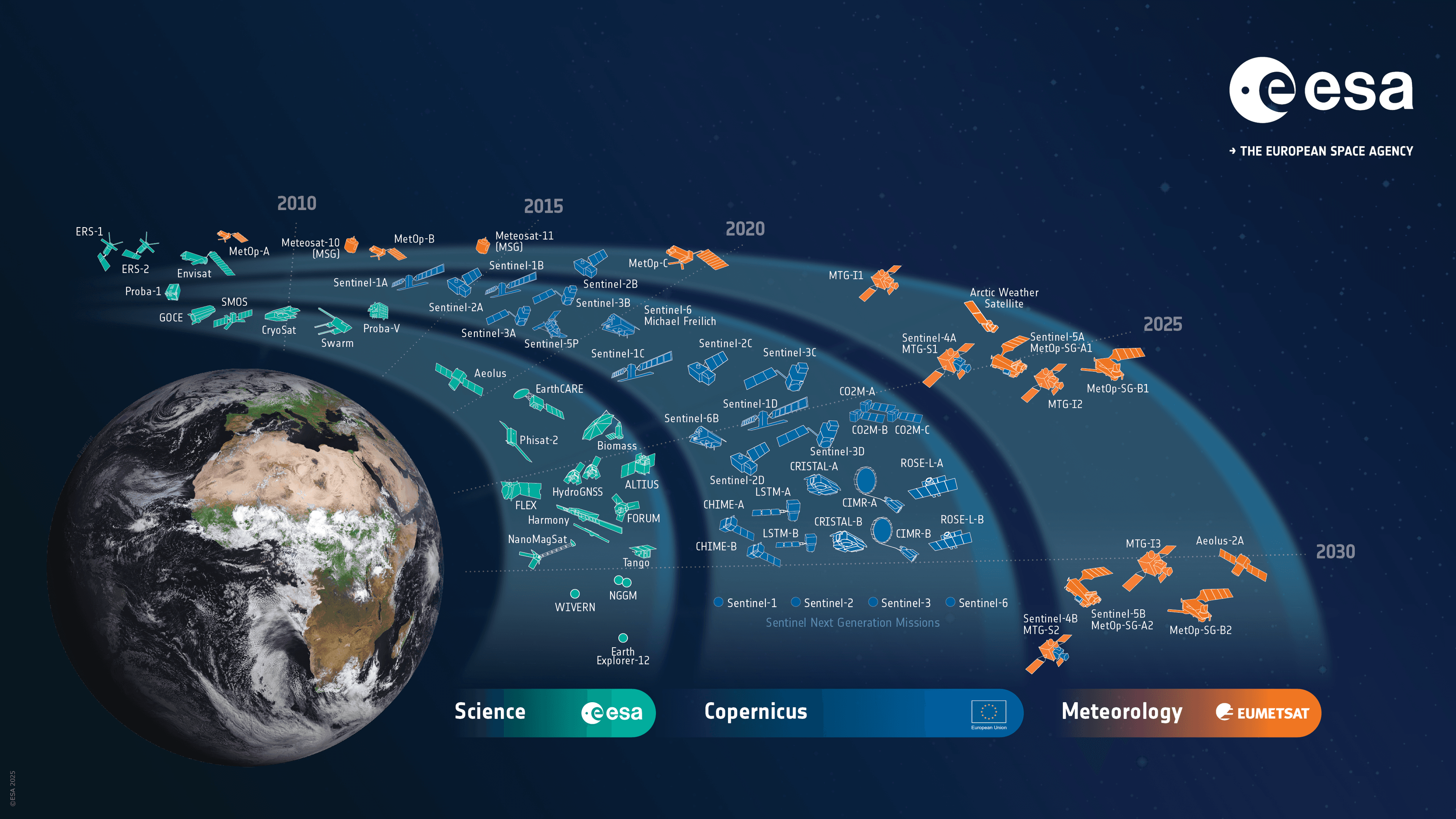
ESA's next-generation Copernicus Sentinels and EUMETSAT's meteorology satellites will integrate with NASA's efforts, creating a global network for comprehensive planetary health tracking.
These tech leaps promise more accurate, timely data, transforming how we respond to climate challenges. These future missions will build on the foundation established by current observations of climate change visible from space and enhance the science of satellite imagery.
Why It Matters for Our Planet
These advancements will sharpen our view of Earth's evolving story, from tracking deforestation to predicting storms. By integrating AI and high-res data, we'll better mitigate disasters, protect biodiversity, and combat climate change—ensuring a sustainable future.
Fun Facts
- Orbital AI Boom: Future constellations could process data equivalent to thousands of EPIC images per second, turning space into a supercomputer.
- Laser Precision: EDGE's altimeter could measure ice sheet changes accurate enough to detect a single snowflake's impact over vast areas.
- Global Eyes: By 2030, over 100 new Earth-observing satellites could launch, dwarfing today's fleet.
Explore Further
Anticipate these futures on DailyEarthView.com as we evolve with new data. Return to today's view on the homepage or delve into the past via our archive. Explore more in our Learn section, like climate change from space or satellite imagery science.
All information inspired by NASA's ongoing missions. For the latest, visit NASA's Earth Science page.